1147 Montricher
- Quick navigation
- Home
- Open menu
- Page content
- Customer service
- Search
- Footer
Win a voucher worth
CHF 2500
Surveying office in Morges
PremiumPremium Entry
Mosini et Caviezel SA
ingénieurs EPFL et géomètres officiels
All Surveying office in Morges
Mosini et Caviezel SA
ingénieurs EPFL et géomètres officiels
Surveying office in Morges
PremiumPremium Entry
Gallery (3)
Opening times Mosini et Caviezel SA
Open – Closes in 32 minutes
- Monday7:30 to 12:00 / 13:30 to 17:00
- Tuesday7:30 to 12:00 / 13:30 to 17:00
- Wednesday7:30 to 12:00 / 13:30 to 17:00
- Thursday7:30 to 12:00 / 13:30 to 17:00
- Friday7:30 to 12:00 / 13:30 to 17:00
- SaturdayClosed
- SundayClosed
- Monday7:30 to 12:00 / 13:30 to 17:00
- Tuesday7:30 to 12:00 / 13:30 to 17:00
- Wednesday7:30 to 12:00 / 13:30 to 17:00
- Thursday7:30 to 12:00 / 13:30 to 17:00
- Friday7:30 to 12:00 / 13:30 to 17:00
- SaturdayClosed
- SundayClosed
- Monday
Mosini et Caviezel SA – Contacts & Location
Add to FavouritesPlease log in first
Edit entryAdd to FavouritesPlease log in first
Edit entryMore locations for Mosini et Caviezel SA
1147 Montrichier / Rue du Bourg 18 Rue du Bourg 18
1147 Montricher021 864 00 40Call
Bureau Route des Roches 8
1042 Assens021 883 00 30*Call*
Description
Contains automatically translated texts.
MOSINI et CAVIEZEL SA
Mosini et Caviezel SA is a design office at the cutting edge of geomatics, civil engineering and rural engineering, established for almost 70 years in Montricher, over 50 years in Morges, since 2007 in Assens and since April 2018 in Rolle. We offer our customers our experience and high-quality technical support to meet their needs and ensure the full success of the various projects entrusted to us. Our design office specializes in the following areas of activity: Geomatics Civil engineering Land improvements Land use planning Gravel pits - quarries Information systems Photogrammetry Computer graphics Competence, efficiency, proximity and modernity are the pillars of our quality and environmental policy. We are ISO 9001 and EcoEntreprise certified. Founded in Montricher in 1950, Mosini et Caviezel SA now employs over 40 people in our four offices. Our team is made up of qualified and experienced EPF and HES engineers, technicians and geomaticians. All of them will make it a point of honor to advise you and help you bring your projects to a successful conclusion.
The company is affiliated to the Ordre Vaudois des Géomètres (OVG)
Services (1)

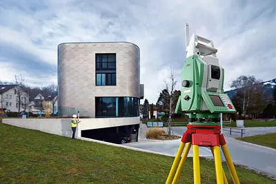
Technologie
Notre bureau est équipé des dernières technologies en matière d'instruments de mesures et d'équipements informatiques.
Nous tenons particulièrement à maintenir nos connaissances et notre parc de matériel au plus haut niveau de manière à pouvoir répondre aux exigences les plus élevées de nos clients et leur proposer des solutions adaptées et novatrices.
Notre bureau dispose actuellement des technologies suivantes :
Instruments de mesures et surveillances
- Drones ultralégers pour photogrammétrie
- Laser scanner
- Récepteur GNSS
- Stations totales robotisées
- Niveaux numériques de précision
Principaux logiciels utilisés
- Autocad Map 3D, Topobase
- Geomensura
- Trimble Business Center
- LTOP, Homère
- Géoconcept, QGIS
- Realworks Advanced, Pix4DMapper, …
PriceOn request
- English,French,German
- Planning & Coordination
- 3D Surveying,Civil Construction,Construction Damage Analysis,Geospatial Data,Infrastructure Construction,Official Surveying,Railway Construction,Road Construction,Subsurface Construction
- Lighting,Telematics
- By telephone,Online
- Close to public transport,In city center,Lake-side,Parking site
- 3D Design
- Fire Protection
- Construction Supervision,Feasibility Studies,Planning
- Categories
- Surveying officeEngineering firms
Languages
Building Technology
Civil Engineering & Geomatics
Electrical Engineering
Forms of contact
Location
Machine and Plant Construction, Product Development
Plastering / Drywall
Services
Services (1)
Technologie
Notre bureau est équipé des dernières technologies en matière d'instruments de mesures et d'équipements informatiques.
Nous tenons particulièrement à maintenir nos connaissances et notre parc de matériel au plus haut niveau de manière à pouvoir répondre aux exigences les plus élevées de nos clients et leur proposer des solutions adaptées et novatrices.
Notre bureau dispose actuellement des technologies suivantes :
Instruments de mesures et surveillances
- Drones ultralégers pour photogrammétrie
- Laser scanner
- Récepteur GNSS
- Stations totales robotisées
- Niveaux numériques de précision
Principaux logiciels utilisés
- Autocad Map 3D, Topobase
- Geomensura
- Trimble Business Center
- LTOP, Homère
- Géoconcept, QGIS
- Realworks Advanced, Pix4DMapper, …
PriceOn request
Similar entries nearby
Chevalier SA, bureau d'ingénieursDAO EXPRESS SÀRLMeylan Ingénieurs SAKälin & Associés SAECM Engineering Consulting & Management SAMP ingénieurs conseils SAAER - Acousticiens ExpertsEcoscan SAEEO Etudes Electriques Olivetta SANicolas Fehlmann Ingénieurs Conseils SABois Initial SALiard & Dutruit SAAssyneo SàrlCSD INGENIEURS SAS + N Ingénieurs