- Quick navigation
- Home
- Open menu
- Page content
- Customer service
- Search
- Footer
Geological office in Aproz (Nendaz)
BEG SA - Géologie & Environnement
BEG SA - Géologie & Environnement
Geological office in Aproz (Nendaz)
Gallery (6)
BEG SA - Géologie & Environnement – Contacts & Location
Description
The Bureau d'Etudes Géologiques SA - BEG - offers services in all areas of geology and the environment related to the interaction of human activities with the subsoil or the exploitation of underground resources.
Composed of a team of experienced geologists and engineers as well as young people trained in the latest techniques, BEG has preserved and developed within its ranks over 45 years of know-how, making it one of the leading players in this field in French-speaking Switzerland.
Originally based in the Valais region, BEG has extended its activities throughout French-speaking Switzerland, and our skills are regularly appreciated beyond the borders.
In construction, the problems most commonly encountered relate to the foundations of structures, the stability of excavation enclosures, underground work and conflicts with the water table.
BEG carries out all the necessary geotechnical investigations (drilling, excavations, penetrometers, laboratory tests) in order to prevent difficulties and propose optimal technical solutions including dimensioning of structures, tendering, invitations to tender, site supervision and quantity surveying. BEG also offers surveillance techniques for geotechnical projects and, in the case of renovation or demolition, asbestos diagnostics.
Foundation
When a simple foundation or subsoil consolidation solution cannot be adopted, other indirect foundation solutions are studied (e.g. bored, driven piles, micropiles).
Geotechnical engineering and excavation shoring
High excavation walls in poor-holding soils need to be reinforced (nailed or anchored walls, Berliner walls, jetting).
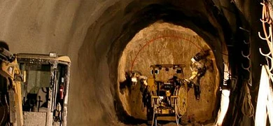
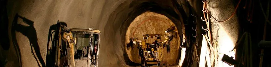
Underground work
Tunnel boring requires a geotechnical study, and site supervision cannot do without a geologist. In this field, BEG has conducted a unique experiment: securing the St-Léonard underground lake, a flooded tourist cavern in a gypsum massif.
Securing the St-Léonard underground lake, a flooded tourist cavern in a gypsum massif.
Sheet overflow
In the case of excavations in the water table, it is necessary to lower the water table by pumping (wells, wellpoints), possibly with the installation of sheet piles. Such situations are modeled using advanced calculation codes to best size the equipment (... more).
Earthworks
The BEG is active in the dimensioning and stability calculations of earth structures subjected to various stresses. These include, for example, equilibrium calculations for natural or man-made slopes, earth dams and dikes, taking into account various factors such as loading, water pressure and suction effects, hydro-mechanical coupling or seismic action.
In this field, BEG is active in the design and stability calculations of earth structures subjected to various stresses.
In this field, BEG is particularly active in securing the dikes of the 3rd Rhone Correction
.
BEG offers solutions to protect the population and infrastructures against:
- landslides
- rockfalls and landslides
- settlements and collapses
- slope erosion
- debris flows
Geological surveys
The BEG carries out expert assessments of geological hazards of various kinds for private individuals and public authorities. These include:
- assessing hazards and vulnerabilities
- propose protective measures in land-use planning projects
- propose appropriate constructive measures in construction projects.
The BEG is also regularly consulted by civil engineering or architectural offices to characterize foundation soils.
Hazard map
The BEG draws up hazard maps linked to earth movements (landslides, collapses) and rock phenomena (rockfalls, rockfalls). Hazard maps for watercourses (floods, debris flows) are produced in close collaboration with hydraulic engineers.
Protective structures
The BEG is often commissioned to draw up defense projects. In particular, this involves:
- dimensioning rockfall protection structures (nets, protective dykes, etc.)
- propose landslide remediation measures (drainage, anchoring, reinforced structures, etc.)
.- propose constructive reinforcement measures for buildings
- plan mining operations
- plan and direct the execution of works (defense projects, drilled drain campaign, netting etc.)
In this field, BEG was involved in the major remediation project for the Frasse landslide in the canton of Vaud (... more).
Monitoring
The BEG develops monitoring programs and installs instruments to track the evolution of natural hazards. Data monitoring and interpretation (setting alert thresholds) provide the authorities with decision-making support in the event of an alarm (...more).
Crisis management
BEG offers alarm plan solutions (customer advice) and regularly supports authorities in managing crises caused by natural hazards.
Monitoring - Natural hazards, construction sites, landfills, quarries, embankments
With its own measuring instruments and staff certified in cliff interventions and hazard management, BEG offers several monitoring methods at very attractive costs. In parallel, BEG manages data processing and interpretation, advises customers on risk management and maintains systems in collaboration, as appropriate, with specialized offices. BEG also offers hydrogeological and environmental monitoring.
Monitoring through in situ interventions
The following services are offered:
- Inspection work
- Installation of indicators and measuring instruments (extensometers, targets, reference points, weather stations)
- Installations of inclinometers (deformation monitoring) and tiltmeters (inclination monitoring)
- Geophone installations for monitoring shaking caused by anthropogenic sources (mining, drilling, vehicle traffic) or natural sources (crack openings, friction, debris flow passages)
The BEG regularly collaborates with surveyors' offices to instrument sites with geodetic techniques (GPS markers, targets for laser sights).
Optical imaging monitoring not requiring in situ intervention
The BEG has acquired 10 years' experience in optical imaging monitoring by developing its own cost-effective methodology for 2D or 3D monitoring of embankments, excavations, rock faces, landslides and glaciers. Acquisitions are made by helicopter, drone or from the ground.
The BEG offers the following services:
- Historical inventories (qualitative and quantitative revaluation of archive images)
- Detection and monitoring of natural hazards
- Construction site monitoring (dimensioning assistance, analysis and stability control)
- Landfill monitoring (logistical assistance, mass balances)
- Quarry monitoring (logistical assistance, mass balances, instability monitoring and detection)
- Bank monitoring (erosion, stability).
Hydrology - hydraulics
BEG offers comprehensive services in water exploitation, recovery and management.
Water disposal
The BEG advises designers and project owners to optimize technically, as well as legally, the management of water to be evacuated from a plot. It also supports municipalities in their monitoring and control work.
The BEG offers the following services:
- advice on integrated drainage management
- sizing of drainage systems (piping, manholes, dumps, pumps, infiltration/retention works, etc.)
- consultancy and checking of sewerage plans
- advice and control of connections.
The BEG includes specialists certified by the Swiss Association of Water Protection Professionals (VSA).
Hydrological hazards
The BEG provides hydrological advice and expertise at plot level for flood, washout and debris flow hazards.
Water management for irrigation
The BEG is active in several projects aimed at optimizing water management for irrigation.
Microturbining
The BEG is active in various mini and microturbining projects, drinking water turbining studies or evaluation of hydroelectric potential.
Hydrogeology covers many fields related to construction, environment, drinking water resources, geothermal energy and regional planning. BEG has experienced hydrogeologists to cover a wide range of services in this field.
Drinking water resources
The exploitation and preservation of drinking water resources is certainly one of today's major challenges. To this end, BEG provides the following services:
- hydrogeological appraisals and resource monitoring (quantity and quality)
- searches for new groundwater resources (aquifers and springs)
- validation of resource potability (water chemical quality, bacteriology, ...)
- sizing and monitoring of drinking water supplies (pumping wells, spring and river catchments)
- establishment of groundwater protection zones for municipalities with catalog of protection measures
- detection of groundwater pollution and identification of the source of pollutants
- numerical hydrogeological modeling using advanced calculation codes.
Constructions
Current guidelines recommend the reinfiltration of rainwater captured by impervious surfaces (roofs, tarred surfaces) into groundwater in order to guarantee its recharge and reduce flood risks. To this end, BEG carries out:
- sizing of infiltration structures
- construction of infiltration structures
Groundwater drawdown is sometimes necessary in geotechnical projects. BEG proceeds:
- the preliminary hydrogeological study
- the sizing of wells by numerical modeling
- to monitor and control the lowering of the water table during construction.
Project interactions - groundwater (study and monitoring)
Any project can have an impact on the water table (flow, regime, temperature, drawdown or pollution). In the event of potential risk, BEG provides the following services:
- quantification of the project's impact on the water table (see also environmental impact studies)
- monitoring
- proposal of measures to minimize project-application conflicts.
In this field, BEG is active in the study of the impact of the 3rd Rhone correction on the water table (... more).
General water evacuation plans (PGEE)
Community water management notably incorporates the reinfiltration of stormwater collected by impervious surfaces in urbanized areas, in order to limit the risk of watercourse flooding in the event of heavy rainfall. In this context, BEG is responsible for identifying areas on the municipal territory that are favorable for infiltration.
Geothermal energy - renewable energy
Geothermal energy refers to a technology designed to harness the thermal energy contained underground. It provides interesting alternatives for individual or collective heating (shallow geothermal energy of low to medium temperature) and, if geological conditions allow, for electricity production (deep geothermal energy of high to very high temperature). BEG has acquired solid experience in this field whether in the exploitation and monitoring of thermal springs or in energy extraction via heat pumps (PAC) and vertical geothermal probes (SGV).
Thermal springs and catchment wells
The tourism, energy and economic potential of thermal springs is considerable. BEG supports project owners through the various stages of a project by:
- prospecting for new thermal water resources
- assessing their potential
- establishing the final projects
- sizing the devices (wells) needed to exploit them
- monitoring the execution of deep wells
.
Thermal exploitation of groundwater - water-to-water heat pumps
Water-to-water heat pumps (AHPs) are an interesting solution in the Rhône plain. However, they are sensitive to water quality and can in some cases interact strongly with neighboring structures if they are not correctly positioned and sized. BEG provides the following services:
- thermal modeling of the water table
- assessment of energy potential
- sizing of pumping and discharge wells used by water-to-water heat pumps
- monitoring the execution of the wells.
Vertical geothermal probes
At depths of 20 m and more, the underground temperature is constant all year round. Individual or field vertical geothermal probes (VGS) can both extract this energy and store any surplus. They are an energy source perfectly in line with sustainable development. However, in order to comply with current standards, precautions must be taken when sizing and executing them.
To this end, BEG:
- sizes geothermal probe fields using Earth Energy Designer
software.- monitors drilling work for these probes.
Deep geothermal energy
At great depths, geothermal potential is considerable, whether or not water is present. In this field, BEG provides the following services:
- establishment of geological models
- assessment of energy potential
- risk assessment (possible seismic activity under certain geological conditions)
In particular, BEG participated in the risk analyses for the City of Basel's geothermal project.
The environment has become a constant concern, particularly in the field of water protection, but also in the management of polluted sites and construction. To ensure compliance with the protective measures required by current standards, environmental safety regulations are drawn up, and regular site visits monitor compliance. During the execution and operation phases, the project requires, in certain cases, stability and/or hydrogeological monitoring.
Environmental impact assessments
Large-scale infrastructures and constructions can have a significant impact on the environment (water, soil, air, noise, fauna, flora, forest, landscape, etc.) which, according to current standards, must be minimized. BEG provides the following services:
- management of studies in coordination with specialized third-party offices
- assessment of project impacts on the environment (natural hazards, influence on water resources,
- proposal of environmentally-friendly measures, taking into account the interests of the project owner
- support to the project owner for authorizations.
Polluted sites
Sometimes, undesirable products can pollute water or soil. In order to protect the population, remediation and/or monitoring is then necessary. In this field, BEG:
- diagnoses and inventories potential polluted sites
- carries out historical and technical investigations to determine the level of water and soil contamination, and to classify the site
- carries out detailed investigations and remediation projects
- supervises remediation work and monitors waste treatment.
Landfills
Current landfills must not generate nuisances, particularly on groundwater. The BEG:
- researches and examines favorable sites for their siting based on environmental, geological and hydrogeological criteria
- proposes technical solutions to guarantee landfill safety (geotechnical stability) and minimize their impact on the environment
- monitors operations
- proposes redevelopment solutions at the end of operations.
Extraction sites (gravel pits and quarries)
Exploitation of mineral raw materials generates a significant impact on the environment and landscape. They require in-depth studies whether for the opening of new sites or the renewal of concessions. In this field, BEG provides the following services:
- prospecting and research
- site prospecting and research
- support to the project owner for authorizations
- establishment of 3D predictive geological models
- site planning and dimensioning (operating mode, geotechnical stability)
- operation monitoring
- redevelopment at the end of operation.
Asbestos - Diagnosis
Asbestos refers to a category of mineral fibers contained in certain rocks (serpentinites, amphibolites).
Between the early 20th century and 1990, this mineral was widely used in industry and building materials. This substance was mainly present in buildings from the 50s to the 70s in a very large number of materials (flockings, tile adhesives, floor coverings, false ceilings, insulation, etc.
.Asbestos fibers, when inhaled, are responsible for several serious lung diseases.
Asbestos diagnosis
If a building was constructed before 1991, it is likely to contain asbestos materials and represents a potential hazard for workers during renovation or demolition work.
The BEG has experts accredited by the SUVA enabling it to offer the following services:
- asbestos diagnostics in normal use or before work
- expert reports meeting the requirements of cantonal authorities.
Asbestos removal
When the presence of asbestos materials is proven, BEG:
- advises on managing the risk caused by the presence of asbestos
- provides prescriptions for the planning and organization of asbestos removal
- monitors the asbestos removal site
Environmental noise-acoustic study and noise control
Noise is very present in our society and often undervalued. Yet it can have negative effects on our health, both physiologically and psychologically, as well as on society and the economy. At present, environmental requirements in general, and those relating to noise in particular, are increasingly stringent. They require projects, of varying scale, to comply with current legislation and be optimally integrated into the natural and built environment.
To meet this need, BEG, in partnership with the EnviroAcoustique office with 25 years' experience in environmental noise, offers environmental acoustic and noise protection studies. The fields studied are:
- industrial and craft noise
- construction site noise
- road noise
- rail noise
- air traffic noise
- noise from shooting installations
In order to address these issues and find integrated, sustainable solutions we offer the following services:
- impact or feasibility studies for:
- new noisy installations
- new noise-sensitive facilities
- noise remediation study of existing facility
- noise cadastre and sound mapping
- in situ measurement and determination of noise levels
- numerical acoustic modeling with CadnaA software (reference software in Switzerland and Europe)
- design and dimensioning of noise protection structures
- advice on drawing up zone plans according to acoustic requirements
- study of compliance with current legislation (LPE, OPB and other cantonal and federal directives)
The BEG has numerous instruments which it makes available to its customers for various types of testing, measurement or monitoring.
Geotechnics
- ME plate tests: measurement of the bearing capacity of an infrastructure or foundation soil.
- Dynamic plate tests (deflectometer): measurement of the bearing capacity of an infrastructure or foundation soil (Ev).
- Autonomous dynamic penetrometer: shallow soundings in loose soils at low cost (over 10 meters deep depending on soil type; ... more).
- Vibration monitor (geophones): continuous measurement of shaking induced by mining or pile or sheet pile driving, jackhammers, road traffic.
.- Inclinometer: measurement of deformation in excavation shoring or landslides.
- Tiltmeter: continuous measurement of wall and terrain inclination
- Drilling camera: auscultation of boreholes and pipelines.
- Deviation monitor: deviation measurement of vertical and horizontal boreholes
Hydrogeology
- Manual and automatic conductivity meters: manual or continuous measurement of electrical conductivity in water
- pH meters: measurement of water pH
- Oximeters: measurement of water oxygen
- Turbidimeters: measurement of water turbidity
- In-situ chemical analysis: measurement of various chemical parameters by titration or colorimetry (iron, sulfates, carbonates,...)
- Manual and automatic piezometric probes: manual or continuous measurement of water level in relation to a reference
- Automatic probes: automatic acquisition of physico-chemical data (pressure, temperature, electrical conductivity,...)
- Gauging devices: flow measurement by dilution (salinometer, electrical conductivity acquirer, fluorimeter) or by volumetry
- Field fluorometer: device for automatic measurement of the concentration of several fluorescent colored tracers for multi-trace testing and/or gauging
- Low-flow pump: pump used for water sampling and laboratory analysis
Monitoring: hazard detection and strain monitoring
- Vibration monitor: continuous measurement of shaking induced by displacements or crack openings.
- Inclinometer: measurement of deformation in excavation shoring or landslides.
- Extensometer: continuous measurement of crack spacing
- Tetrahedron remote transmission system: equipment connected to a measuring instrument enabling data to be transmitted remotely
- Tiltmeter: continuous measurement of wall and ground inclination
- High-resolution camera: camera for tracking deformations by 2D or 3D image processing (photogrammetry)
- Drone: flying wings and quadricopters for surveying difficult-to-access sites or for photogrammetric surveys
- French,Italian
- Construction Preservation,Geospatial Data,Property Drainage,Structural Dynamics (Seismic Safety),Subsurface Construction
- By telephone,Online
- Parking site
- Design,Expertise,Planning,Tendering and Bid Comparisons
- Categories
- Geological officeEngineering firmsGeotechnics